Drone-Analytics

AI Powered

All in one Drone
Data Analytics Solutions

Drone Based Surveying | Project Monitoring | Inspection | AI Based Video Analytics ​

Roof/Solar Panel
Measurement And Inspection

1.

Construction Project &
Safety Monitoring

2.

Land Acquisition, Optimization &
Inspection

3.
4.

Agriculture Health &
Yield Analysis

Wind Turbine, Tower &
Oil/Gas Inspection

5.

Traffic Optimization &
Queue Analysis

6.

Survey & Planning - Industries​

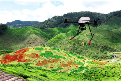
Sturdy and powerful, our drones can be used in challenging conditions without limiting their capability to generate adequate data. With extensive capabilities for land inspection, survey and mapping, thermal inspection, traffic planning, and safety monitoring, our drones will bring you comprehensive data. The data thus collected will help you know everything that you want to learn about your current projects or important details about potential projects for decision-making.
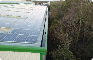
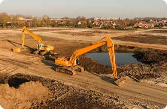
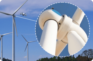
What makes our Drone Analytics Solution even more impressive is the fact that you can use it for a range of industries. No matter, if you are running your project in the energy, engineering, civil and construction, mining, agriculture, or transportation field, our solution, will be the best support that you can get. Our solutions are designed to withstand the taxing conditions of most industries.
Our Drone Data Analytics Solutions have been designed to match the requirements of the clients perfectly after a series of tests and simulations. This helps us ensure that the clients would be immensely benefitted by our solutions. When we develop our drone survey & planning solution, we took into consideration all the challenges that the clients would face and customized the same to render the best solutions for them. This has made us one of the best drone survey companies in the field.

Using Drone & AI powered Data Analytics we can do:​

Roof/Solar Panel Measurement and Inspection

For businesses working in the solar panel business, sometimes it would be impossible to inspect the roofs by human resource. However, our All-in-One drone analytics…

Construction Project & Safety Monitoring

Our services are feature-rich with the capability of overlaying project details in sync with drone parameters to get the most comprehensive assessment of construction projects for safety …

Land Acquisition, Optimization & Inspection

Land acquisitions can be a hard job especially if the land spans hundreds of hectares. However, no matter what your ultimate goals are, our All-in-One drone analytics solutions…

Agriculture Health & Yield Analysis

For farmers and industrial agriculturists, analyzing the health of their crops and yield is extremely important to ensure that they are able to generate adequate returns on their investment…

Wind Turbine, Tower & Oil/Gas Inspection

It was not possible to carry out extensive and close inspection of various turbines, towers and oil/gas systems. However, it has become possible now with our drones for wind turbine/tower…

Traffic Optimization & Queue Analysis

Businesses need to care of the traffic at their facilities and have a comprehensive view of the vehicles entering and exiting the campus. However, it may not be entirely possible with traditional…

Survey - Applications​

  • Inspecting inaccessible areas​
  • Thermal data with insights on surface temperature
  • Identifying oil spill and rust areas
  • ​​Insights on trends of damages over time
  • ​Monitoring encroachment in ROW of laid lines
  • ​Wind turbines, power transmission lines, flare stacks, lattice towers, pipelines​​​​​
  • Outputs: RGB imagery, Thermal imagery, Radiometric data, Report on damaged sections​​

Our Solutions

We bring you a plethora of drone data analysis solutions that will help you inspect and review a range of projects to ensure their intended progress. Whether you are working in the construction, realty, and oil & gas industry, our All-in-One drone data analytics solutions will help you immensely in upping the efficiency of your project execution and the project itself. As a result, with the help of the drone data analysis you carry out, you can certainly bolster the effectiveness and efficiency of the projects that you undertake. As a client-centric service provider, we have also worked hard to create our solutions as customizable and scalable as possible to make them fit the changing requirements of the clients perfectly. When you use our drone survey solutions, you are making one of the best decisions that will change the trajectory of your project undertake for sure. With the help of our drone data analysis, you can arrive at insights that you would not have been able to otherwise. Hence, you can make the best, informed, and data-backed decisions to execute your projects immensely well. Although there are numerous drone analysis companies in the field, what makes our service unique is the presence of a myriad of options that our drone survey solutions offer. Hence, no matter what type of support you are looking for in your project execution stage to collect survey data, our solutions are the best for you.

Aerial Survey

Large area mapping, topographic survey, GIS, 3D models, ortho, DSM, DTM, contour, volumetric calculations, solar rooftop potential.​

Computer Vision, Machine Learning, Artificial Intelligence​

Large area mapping, topographic survey, GIS, 3D models, ortho, DSM, DTM, contour, volumetric calculations, solar rooftop potential.​

Critical Asset Inspections​

Wind turbine blade, transmission line, flare stack, oil & gas pipelines, solar panel inspection, industrial plants.

Cloud Based Dashboard​

Web app for easy sharing, collaboration and analysis, video & image annotations, report generation, easy data archival & retrieval.​

Ready to grow your business? Get in touch.